The Panama Canal amazes the world with the latest multibeam echo sounder technology
The Panama Canal is probably the best known ship canal in the world and it never fails to amaze those that have visited it, and particularly those who have passed through. This key ship canal in Panama has been connecting the Atlantic Ocean (via the Caribbean Sea) to the Pacific Ocean uninterruptedly since its official opening in August 15, 1914. The canal was designed to cut across the Isthmus of Panama, and has become one of the most important navigational channels for international maritime trade in the entire globe.
The heavy traffic as well as the expansion operations of this important waterway called for a reliable and more efficient method to conduct the hydrographic surveys throughout the most critical areas of the Canal.
Channel maintenance at actual navigational depth for vessel traffic is critical and needs to be maintained within safe depth ranges in the Pacific and Caribbean channel areas. The daily hydrographic applications also include supporting dredging operations and flood control, the latter is critical in the artificial 'Lake Gatún'. The applications are diverse and depend on the specific daily needs of the Panama Canal Authority.
Hydrographic Surveying has been a science of great importance in the history of the Panama Canal since its construction date. Singlebeam technology was extensively used until recent years.
Acoustic sound transmission represents the basic techniques for underwater navigation, telemetry, singlebeam / multibeam echosounders and sonar technology. Common for all is the use of underwater pressure wave signals that propagate through the water at a certain speed of sound (typically at an average of 1500 m/s). When the pressure wave hits the sea bottom or another object, a signal is reflected back and detected. The reflected signal contains information characterizing the reflected object. The sea is far from an ideal transmission medium, with acoustic noise and multipath interference as some of the major concerns.
Multibeam bathymetry is based on the fact that several beams are better than one. They map the seafloor by generating several hundred beams over a crosstrack profile for each ping, and each beam generates at least one depth sounding. While the platform sails forward the seafloor is covered with a dense pattern of soundings producing high-resolution bathymetry data and geo-referenced high resolution seabed imagery throughout the survey area and thus providing 100% coverage of the seafloor.
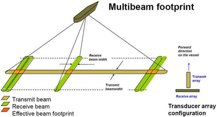
Different multibeam echosounder models are available for different water depth requirements and several versions of each model are available with different resolution capabilities. A typical multibeam system consist of four units, a transmit transducer, a receive transducer, a transceiver unit and an operator unit.
The transmit transducer is long in the alongship direction and short in the athwart ship direction; enabling the system to generate a swath of sound which is wide in athwart ship and narrow in the alongship direction. The receiver is wide in athwart ship direction and narrow in the alongship, enabling the system to receive the wide swath produced by the transmitter, but still have narrow beams in the along track direction.
The sound generated by the transmit array, is reflected by the seafloor at different angles and is received by the receiver transducer at slightly different times.
The footprint is formed by the intersection of transmit and receive beams (see image below). All the signals are then processed by the transceiver unit, converted into depth values and plotted as a bathymetric map on the operator unit.
These multibeam systems have the following capabilities in real time:
- The transmitters have individual control of all the single elements in the array. This may be used to form several transmit beams and to stabilize for roll, pitch and yaw in real time.
- Pitch stabilization in real time. Stabilization for pitching is obtained by steering the transmit beam electronically forward or aft at the time of transmission, based upon input from the motion sensor.
- Roll stabilization in real time. Each Receive Beam is stabilized for roll by the Beamformer, using input in real time from the Motion Sensor every 10 ms. All beam pointing angles are thus constant, related to the vertical axis.
- Yaw stabilization in real time. These systems have the option to be fully stabilized for yaw by using sector transmission with frequency coding and individual tilt control, enabling simultaneous transmission on all sectors.
- Heave compensation in real time. Each beam has its individual heave compensation, using input in real time from the Motion Sensor.
- These multibeam systems also apply Sound Velocity Correction in real time. The basic algorithm performs a ray tracing process through the water column for each beam using an 'intersection of cones' technique that is unique. It also computes the steered beam angles based on the surface sound speed – at the transducer. The result of this procedure will be a depth solution datagram that contains along-track, across-track, and reduced depth values for each beam.
- High density signal processing and near-field beam focusing. The following beam spacing techniques are available: equiangular, equidistant, high density equidistant. The horizontal resolution is much improved due to the introduction of focused beams for both transmission and reception and the high density signal processing technique. Near-field focusing is essential for retaining angular resolution. On reception near-field focusing is done dynamically (focal point is shifted as function of time/range) and on transmit each sector will have independent focal points.
- Extended coverage by use of chirp technology. The use of new frequency independent hardware makes it possible to generate other signals than continuous wave (CW) pulses, like frequency modulated chirp (FM) waveforms for extended range performance and with pulse compression on reception. The use of FM gains approximately 15dB in signal-to-noise-ratio compared to CW pulses.
- Maintaining all beams in the swath. In some applications or due to weather condition the user might want to reduce the swath width. If so, the systems will not cut-off the outer beams, but will maintain all beams in the new coverage sector set by the operator. Hence, both the resolution and the ping rate will increase. This is a unique feature and very useful when surveying a wreck or feature on the seabed. The operator may also select a maximum coverage to ease the line planning in sloping terrain. The system will then run in an automatic mode and maintain all beams within the selected coverage.
- These multibeam echo sounders not only collect high resolution bathymetry and seabed imagery, they're also capable of recording the water column data.
The EM 3002 and EM 2040C multibeam echosounders (used in the Panama Canal areas since year 2011) have revolutionized the way that hydrographic surveys had been historically conducted over the years inside the Panama canal.
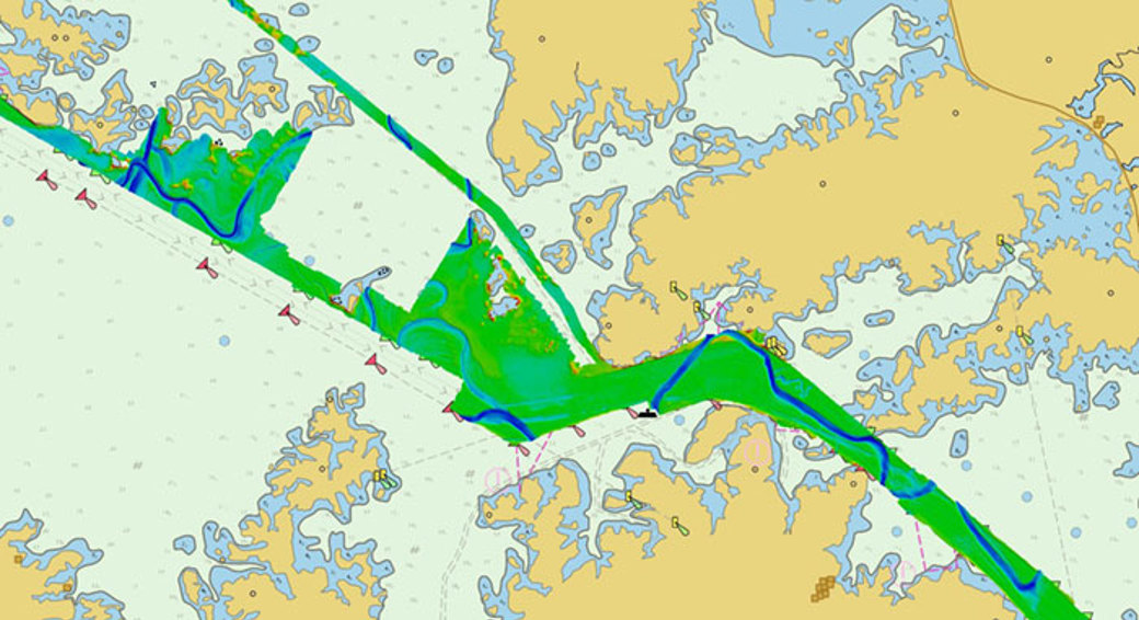
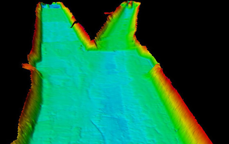
The average depths in the current working areas range from 16.76m to 18m. The wide swath coverage of the multibeam systems allows to cover the 200m width channel areas with very few survey lines, which includes mapping the foot of the slope on both sides of the navigational channel; the latter is a very important task for inspection purposes to detect bottom scour, slope failures or also massive slumping of seafloor.
The demanding tasks in today's operations are intended to double the capacity of the Panama Canal by creating a new lane of traffic and allowing more and larger ships. Dredging control and monitoring operations are conducted almost daily. The expansion works are currently focused in widening Corte Culebra area and the northern areas of Lake Gatún.
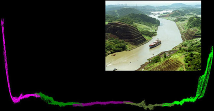
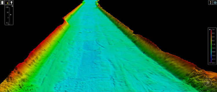
The implementation of multibeam echosounders has also impacted the data processing times as well as the delivery of the cartographic products. For example, in the area of Corte Culebra (see picture above) what used to take days (with previous multibeam systems) from data acquisition to data processing and final products now takes only a couple of days. Time at sea conducting hydrographic surveys has been reduced and productivity has increased immensely.
Real time data processing and visualization software gives the surveyors immediate information about the progress of work and the quality of the data that is being collected.
After 5 years of continuous data collection with the multibeam systems the vast amount of datasets processed so far also require the use of the best post-processing techniques and commercial off-the-shelf software to guarantee a high quality of the final products that need to be generated and store for data analysis and decision making.
A third, wider lane of locks is currently under construction and is due to open in 2016. With the new expansion works of the Panama Canal we hope that a new generation of multibeam systems will continue to prove that these systems are the most reliable and convenient seafloor mapping tools for shallow water hydrographic surveys.
"KONGSBERG has provided high resolution multibeam echosounders for shallow water hydrographic surveys to Panama Canal Authority (ACP) for five years. We recently held an international multibeam seminar in cooperation with ACP and we thank them deeply for this opportunity to strengthen our relationship and advance hydrographic survey capacity building in the Americas. ACP's application of our multibeam systems for the vital canal expansion program is a success story worth sharing with the rest of the world", said Chris Hancock, Vice President of Sales, at Kongsberg Underwater Technology Inc.
The Panama Canal Authority continued success with their multibeam systems comes with hard work; their hydrographic teams rely on dedicated highly qualified survey engineers that are operating almost every single day of the week in different areas of the Panama Canal from the Atlantic to the Pacific Ocean.
This successful story is worth sharing with the hydrographic world. These technological advances in the field of Hydrography are very important to Panamanians; tools that have come to stay and revolutionize the marine industry in Panama and Central America.
Authors
- B.Sc. FIG-IHO CAT-B José Alexis Primelles Cardenas Sales Support / Hydrographic Support SpecialistUnderwater Mapping, Kongsberg Maritime
- M.Sc. Jorge F. Rodriguez COceanographic and Marine Resources Expert Hydrographic Surveying Department, Panama Canal Authority (ACP)