The multibeam echo sounder EM 3002 (since then available in a new version the EM 2040), extends the functionality of multibeam echo sounders to cover 3D imaging of biomass and other acoustic reflectors that might be present in the water column. 160 acoustic beams are sampled digitally with a spatial resolution of 15cm for each ping, creating a digital image of a slice of the water mass under the transducer. When the ship is sailing forward, a 3D description can be obtained by combining the images from several pings.
The raw display image is available as part of the operator interface. An option to the SIS operating software allows storage of the beamformed water column data to disk. The Tasmanian Company SonarData has extended its Echoview software to reading and post processing the water column data files, and to visualize the information as 2D or 3D images.
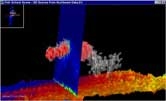
This new feature makes the EM 3002 perfect for surveying of fishery habitats to a max depth of about 150m, offering simultaneous and co-registered data collection of bathymetry, seabed backscatter imagery and water column backscatter imagery. Another interesting application may be wreck surveys, using the raw water column imagery to determine the minimum depth. The raw imagery will reveal masts or other small structures which may be difficult to map correctly by using the bathymetric data only.