Critical infrastructure
Critical infrastructure is more than just physical structures; it is the lifeline of our modern society.
It refers to the systems, resources, and services essential for society’s security, health, economy, and welfare. It encompasses many sectors, including energy, water supply, transportation, finance, telecommunications, and healthcare. It includes the power that provides us with light and heat, the pipes that supply us with clean water, the signals in the air that give us mobile coverage, the servers that provide us with internet access, the planes that take us on vacation, and the ships at sea.
Infrastructure is all around us, and protecting these systems is crucial to ensuring society can function normally, even in crises.
With operational areas of interest as large as oceans, it pays to have a high-level view of assets, activity and an ever fluid risk picture.
Satellites help tackle the challenges of conducting surveillance at scale, monitoring and analysing marine activity on a local, national and international level to enable informed, fast and optimal decision making.
From seeing the ‘big picture’ to diving into the details of individual vessel activity, satellites provide a platform for the identification and prediction of potential risk, enabling opportunity for timely action to safeguard critical infrastructure.

AIS Space Receivers
An AIS (Automatic Identification System) space receiver is used to receive and decode AIS signals from ships. These signals contain information about the ship’s identity, position, speed, and course. By placing AIS receivers on satellites, it’s possible to track ships over vast ocean areas where terrestrial AIS receivers can’t reach.


The ocean is challenging for engineers. Increased water pressure and harsh conditions degrade structures underwater. Yet, these structures are difficult to access, inspect, and assess. Ports and harbours, dams, inland waterways, locks and canals, bridges, and offshore structures all require periodic and unscheduled inspection.

Image: PS-Survey
Structural inspection imaging
Hard dockings can damage vessel berths. Barge and tug collisions can damage bridge piers. Strong winds and ever larger vessels can damage mooring systems. As a result, these structures must be closed for safety inspections.
It is crucial to conduct these unscheduled inspections quickly and effectively so operations can resume. There should be no doubt that the structure is safe to use. These inspections are typically conducted by divers. But, in many cases, diver-based inspections can be unsafe or disrupt operations. In addition, many inspections are conducted in water with low or zero visibility. In these situations, imaging sonar is a valuable tool for dive teams.
Sonar instruments make diving inspections safer and create visual images of the structure being inspected. These images help civil engineers make informed decisions on the structure’s condition. They can then plan emergency-corrective maintenance accordingly.
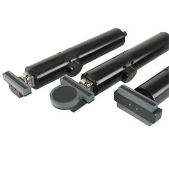
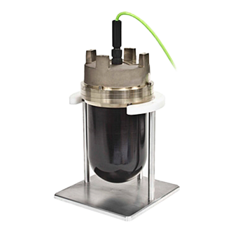
High resolution 1171 sonar heads
A powerful inspection tool when paired with ScanFuseTM image-processing software. The image quality of single beam scanning sonar is superior to multibeam data, particularly when looking for features, such as cracks and fractures. ScanFuseTM creates a complete image of the structure by splicing high-resolution sonar scans together automatically.
Read more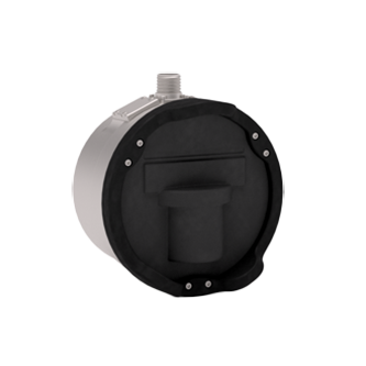
M3 Sonar HF
The M3 Sonar HF is a high-frequency multibeam sonar with both imaging and profiling capabilities in one sonar head. This multibeam sonar is an exceptionally good option when speed is essential, but image quality is also important. Using the M3 Sonar HF with SoundTiles mosaicking software provides automatically-mosaiced multibeam images. Using this sonar with HYPACK Hysweep provides 3D pointcloud data for inspections. The M3 Sonar HF is available in several system configurations suitable for ROVs, manned, and unmanned vessels.
Read more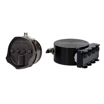
Infrastructure Inspection Solutions
The Infrastructure Inspection System is an advanced solution designed for infrastructure inspection, ideally suited for small survey boats with over-the-side pole mounts or USVs.
Read more


Rivers and tides can create shallow areas or cause siltation and scour. These changes can occur slowly, or extremely rapidly. The speed of water flow can vary dramatically from low tide to high tide. Drought and heavy rainfall can also play a role. Scour can cause sudden catastrophic failure of bridge piers, which is why several federal regulations focus on the importance of inspecting scour-critical bridge piers regularly.
Scour can also pose a risk to port infrastructure. Commercial vessels are larger, and their propulsion systems are more powerful. Propellers and thrusters undercut bulkheads and scour deck piles. In doing so, they deposit the material elsewhere in navigation channels. Civil engineers must monitor for scour and take corrective action to protect ports.
Dual Axis Sonar with K-Observer
Permanently install the Dual Axis Sonar (DAS) to see change over time. Whether that change is scour, shoaling, siltation, or the sudden deposit of storm debris in the scanned area – you can continuously monitor critical infrastructure. K-Observer supports up to four Dual Axis Sonars, which generate a 3D point cloud of the area of interest.
K-Observer then uploads data to the Cloud, where you can compare scans to see differences in the bottom condition. Dual Axis Sonars can monitor scour of various structures, including wind-turbines, dam intakes, reservoirs, bridge piers, and berth pockets. K-Observer is scalable and can cover unique situations with multiple elements like bridge piers on a long span, or multiple monopiles in a wind farm array.
Dual Axis Scanning Sonar
The Dual-Axis Scanning (DAS) Sonar is a profiling system designed for long-term seabed or structure monitoring.
Read more

Critical subsea infrastructure may be out of sight, but it should never be out of mind.
With power and communication cables, energy pipelines, and vital installations crisscrossing the seafloor, the need for continual monitoring and robust inspection practices is paramount.
However, the scale of developments, the depth of deployment, and the often-demanding operational environments create obvious challenges for owners, operators, governments and other key stakeholders.
These challenges must be overcome to counter threats ranging from corrosion, marine growth, and physical damage from currents, through to accidental damage from human activities, and planned attacks.
![]()
Autonomous Underwater Vehicles
Underwater infrastructure can be monitored using marine robots that reduce the need for human surveillance, thereby enhancing safety, saving time, and reducing costs.
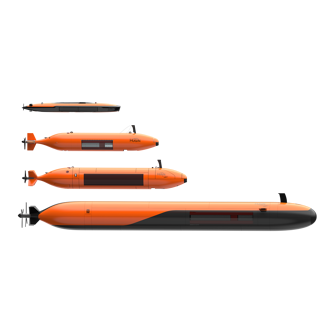
Hugin AUV
Our HUGIN AUVs has provided advanced autonomous subsea surveillance capabilities for over 30 years. It is suited for patrolling and inspecting pipelines, power lines, communication cables, and other subsea structures. The HUGIN Endurance can cover up to 2,200km in one mission and operate at depths of up to 6000m with a navigation accuracy of 0.04% distance travelled. Its sensor package, along with surface in situ and post-processing, makes it effective for high-resolution underwater observation to maintain subsea infrastructure integrity.
Read more

Learn more about our solutions?
Need help deciding on what type of equipment you need? Interested in learning more? Don't worry, get in touch and our experts will help you.
Downloads
We offer comprehensive after-sales assistance
-
24/7 Technical support
Our Technical Support team is readily available to provide global 24/7 support and can respond to resolve any issues at any time, wherever you are located in the world.
-
Training
We can provide detailed training on the use of our products to ensure your crew is equipped with the necessary operational competence to minimise technical risk and maximise return on your asset investment.