TOPAS (Topographic Parametric Sonar) is utilised to view a crosssection of the seabed, explore the sediments and detect submerged objects. Senior system engineer in subsea acoustics, Johnny Dybedal, calls the system a “seabed penetrant echo sounder”. While a normal echo sounder only reflects off the seabed, TOPAS penetrates the actual seabed and allows its users to view different structures and layers in the sub-seabed layers.
“When using high frequencies, the sounds are reflected off the seabed. The TOPAS products make use of much lower frequencies, from 500 hertz and up to 10 kilohertz. With such low frequencies, the signals can penetrate the seabed and are reflected by the different layers of sediments. The technology in itself is actually quite old. All we have done is develop certain other methods of generating these low frequency signals. TOPAS has a narrow sound ray, typically 4-5 degrees, and can therefore also reproduce clear details in the sediments. What’s more, the equipment is fitted on the boat while previously it would often have to be towed behind a boat.”
“If the signals can penetrate the actual seabed, why is it that they reflect back off the layers of sediment?”
“Because the different layers have different qualities. They could be of mud, sand or rock. When you have two layers with different qualities, you have the same effect as with the interface between water and the seabed. The signals are reflected and the display in the boat shows the structure of the sediments.”
“Could TOPAS be used to provide information on other objects located down there in the sediments?”
“Yes, the most important area of application is viewing the actual structure of the sediments. If, for example, you want to lay a pipe, it’s important to find out whether it can be submerged or if the bedrock is too close to the actual seabed. TOPAS can provide its users with such information, for example where to position a platform on the seabed so that it can stand steady.”
“Is TOPAS also used to explore for oil?”
“Not for normal oil exploration, no. But it does allow us to detect organic gas in the seabed sediments. When the sediment is soft, we can penetrate to more than 200 metres below the seabed, but cannot penetrate the bedrock. With sand, penetration is only possible down to some tens of metres. There is such a high variation because the way in which the different sediments muffle the signals varies so much.”
“What kind of vessels make use of TOPAS?”
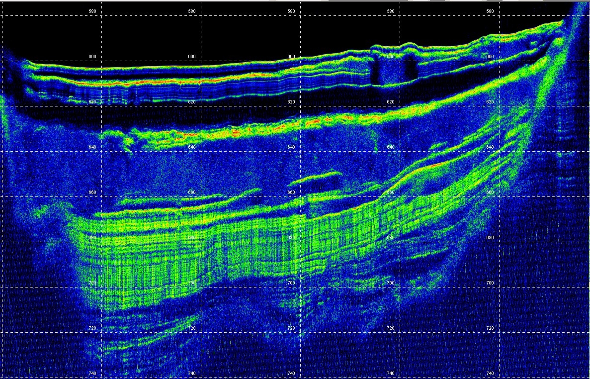
“They range from research and survey vessels to military vessels (MCM). We have two different systems. The smallest can be used on boats from 30-40 feet and longer. The largest systems are designed for boats from 100 feet and more. The intensity of the echo is displayed in colour codes for the users, allowing them to view the actual seabed and the echo on the bottom, so that the interfacing surfaces between the different sediment layers become more clear. The information available from the system can also be used to calculate the volume of the different sediments. As an example, the NGU (the Norwegian institution for knowledge on bedrock, mineral resources, surficial deposits and groundwater) has utilised TOPAS to chart so-called shell sand.”
“Another obvious question is whether this technology could also be used as an advanced form of treasure hunting?”
“Ha ha. TOPAS could definitely be used to find objects buried in soft sediments. I’m not sure whether it has been used for treasure hunting, but it has been used to locate pipelines and find out how deep they are buried in the sediments. However, most of the systems have been installed on research vessels throughout the world and are used to study subsea rock falls, the stability of the seabed, sediment structure and a number of other elements.”